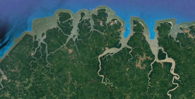
Those who live in the Amazon can recognize the estuary's importance that surrounds them. In estuaries, organisms reproduce, feed, and live. They are nature nurseries. On the Amazon coast, the estuaries have connections, the so-called tidal channels or “boreholes”, which serve to interconnect each estuary. In these “holes” there are exchanges of water, transport of sediments, nutrients, and biomass (Ramírez et al., 2012).
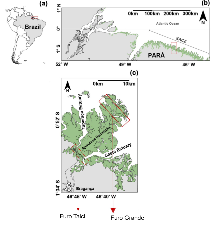
This connection and components exchange between estuaries can be seen in the study by Gomes et al. (2020), at Furo Grande and by Araújo & Asp (2013), at Furo Taici, both located between the Caeté and Taperaçu estuaries, in Pará (Fig. 1). To assess the connection of the estuaries, the authors observed the spatial and temporal variations of morphology and sedimentology along the channel, in addition to analyzing the variation in water level, salinity, currents, concentrations of suspended sediments, and sediment transport.

Figure 1. The location of Furos Grande and Taici connect the Taperaçu and Caeté estuaries. Source: Gomes et al. (2020).
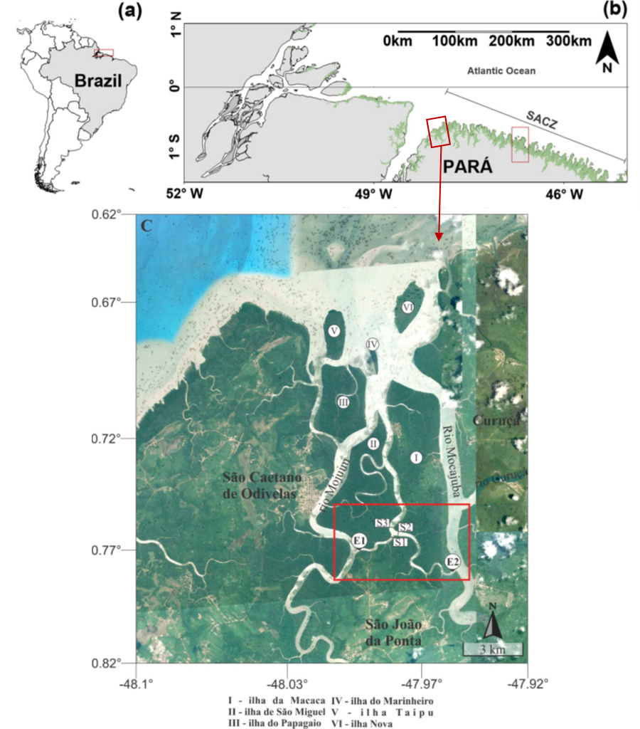
Both studies observed high connectivity between the estuaries, however, both tidal channels showed preferential flow from the Caeté to the Taperaçu estuary, observed in the hydrodynamic and also sedimentary analysis. In the Amazon, each estuary is connected to its neighbors by tidal channels, such as Furo Grande and Furo Taici. Another example of the interaction of estuaries can be seen in the connection between the Mojuim and Mocajuba estuaries (Fig. 2), located to the left of Taperaçu, much closer to the Pará river (Corrêa, 2018). Similar to the other two tidal channels, this channel allows the flow's exchange between the estuaries during the flood and ebb tide.
Thus, we can observe that the presence of these “holes” is extremely important for the transport and exchange of fine sediments, nutrients, and biomass, between the estuaries. This becomes more evident when we analyze the Amazon on a macro-scale and observe the largest continuous mangrove belt on the planet (Souza-Filho, 2005), located here, in our Amazon.

Figure 2. Location map of the estuaries of the Mojuim and Mocajuba rivers, in the São Caetano de Odivelas city, and the tidal channel that connects them. Source: Gomes et al. (2020) and Corrêa (2018).
References
Araújo Jr, Wilton Pires; ASP, Nils E., 2013. Hydrodynamic connectivity between two macrotidal Amazonian estuaries. Journal of Coastal Research, (65), 1086-1091. https://www.researchgate.net/publication/278192453_Hydrodynamic_connectivity_between_two_macrotidal_Amazonian_estuaries
Corrêa, A. W. R., 2018. Conectividade estuarina amazônica: um estudo de caso entre os rios Mojuim e Mocajuba. 75 f. Trabalho de Conclusão de Curso – Faculdade de Oceanografia, Instituto de Geociências, Universidade Federal do Pará, Belém. http://bdm.ufpa.br/jspui/handle/prefix/852.
Gomes, V. J., Asp, N. E., Siegle, E., McLachlan, R. L., Ogston, A. S., Silva, A. M., Nittrouer, A. C., & de Souza, D. F., 2020. Connection between macrotidal estuaries along the southeastern Amazon coast and its role in coastal progradation. Estuarine, Coastal and Shelf Science, 106794. https://www.sciencedirect.com/science/article/abs/pii/S0272771419310649
Ramirez, J.A., Poillon, M.S., Gomez, M.A.M., Leon, D.A.S., 2012. Export of materials along a tidal river channel that links a coastal lagoon to the adjacent sea. Brazilian Journal Of Oceanography, 60 (3), 311–322. https://www.scielo.br/scielo.php?script=sci_arttext&pid=S1679-87592012000300004
Souza-Filho, P.W.M., 2005. Costa de Manguezais de macromaré da Amazônia: Cenários morfológicos, mapeamento e quantificação de áreas usando dados de sensores remotos. Revista Brasileira de Geofísica, 23 (4), 427–435. https://www.scielo.br/scielo.php?script=sci_arttext&pid=S0102-261X2005000400006

Ótimo trabalho!
Após perder muito tempo na internet encontrei esse blog
que tinha o que tanto procurava.
Gostei muito.
Meu muito obrigado!!!
Nós que agradecemos! Ficamos muito felizes que nossos conteúdos lhe agradam!